|

The"Aorounga" structure in Chad is
NOT
an Astrobleme
Norbert Brügge, Germany
Dipl.-Geol.
The Aorounga and
Gweni-Fada
structures in Chad (Africa) are classified as astroproblemes by certain dogmatic
scientists due to dubious evidence, e.g. planar deformations in quartz grains.
It should meanwhile be known that such "evidence" can be completely nonsensical
in the context. It has been shown that such deformations can also be generated
by volcanic shock waves of different power, this applies to both PFs and PDFs.
PDFs are only genuine if certain features can be verified by a TEM examination.
Even then, PDFs are not yet a feature of an impact, because the PDF-paradigm
is based on findings in impact structures in question. Likewise, the necessary
shock forces for the formation of PDFs cannot only be induced by an impact.
The same applies to so-called impact breccia, which are used again and again
without precise examination. Even a centrale uplift is not suitable as proof,
the so-called "target rocks" are not a "pudding" after all. The mostly of
the structures defined as impact craters around the world are not anyway.
The Aorounga structure has received
little on-site investigation. A first description was published in Becq-Graudon
et al. (1992). The expedition Vincent & Beauvilain (1994) provided
the latest increase in knowledge. Breccias were also collected to microscopically
examine possible planar features in quartz.The results are published in
Koeberl et al. (2005). Some impressive photos from 1994 with commens were
published by Alain Beauvilain (1996) and are essential to the evaluation
of the Aorounga structure, in addition to other descriptions.
|
|
Alain Beauvilain,1966
Quotes (translated)
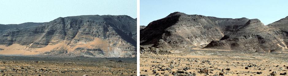
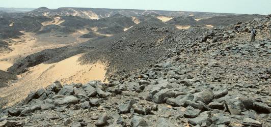
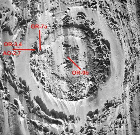
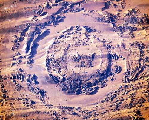
"The Aorounga structure have a diameter of ~13 km. This crater-like structure
is well defined, with a broad, near-circular central area of an obvious
hilly terrain, of ~9 km in diameter. It is surrounded by a flat annulus
(maximum 3 km wide), which shows at its outer edge disturbance of circular
geometry. Especially in the western and southwestern sectors, a distinctly
hummocky (mountainous) ring encloses the flat annulus. It is, however,
difficult to identify how far out this ring structure extends, especially
in the northeastern and southwestern sectors where the crater structure
is surrounded by complex terrain."
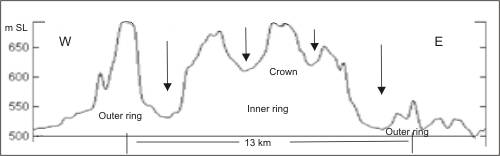
"The crater interior shows a small, irregularly shaped central peak area
surrounded by a somewhat flatter ring, in turn surrounded by a broad and
topographically strong ring. Aorounga structure is recognized as a multi-ring
structure, which comprises a central, somewhat hummocky area, surrounded
by a near-circular and 2 to 3 km wide ring feature of strong elevation,
followed by the flat annulus and then by an outer ring as a feature that
surrounds the entire crater structure, presumably the actual crater rim
zone. The depression (a flat terrain around the central complex) is about
2 km wide and of even elevation in all four sectors of the crater structure.
This feature is surrounded by a 3 to 3.5 km wide zone (outer ring) of
variable but always significant relief. This ring feature probably represents
the apparent crater rim. "
"The structure is characterized by an outer and an inner ring (diameters
of ~11 and 7 km, respectively), which both rise about 100 m above the
mean level of the surrounding plain The two rings are separated from each
other by a depression of uniform width. A hill, or possible uplift structure,
of ~1.5 km in diameter is located near the center of the central depression.
The ring walls were described to consist of steeply outward dipping sandstone
layers, with dips of 40–50° seen at the outer wall and 80° at the inner
wall. Some breccia as consisting of a coarse-grained siliceous matrix
with fine-grained, beige clasts
(cm- to dm-size) with fluidal texture, was apparently found on top of
the inner rim wall."
"No melt-bearing samples that might provide a key
for dating of the impact event have been identified among the limited
sample suite available "
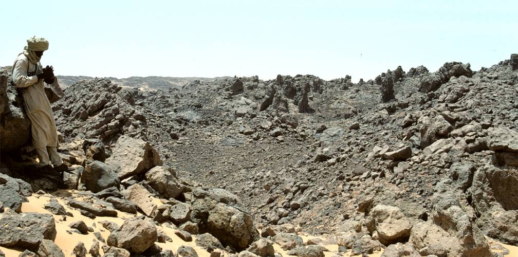
"The outer wall is higher in the west than in the east. The outer annular
depression has a regular width of 2 kilometers. To the west it is up to
150 meters deeper than the outer wall.
Structurally, it is a fault-bounded
"Syncline-Graben". The sandstone formations tumble down on each side with
dips that can reach vertical to the foot of the edge."
|
"The peripheral crown has an unequal width
of 3 to 4 kilometers and forms a western boundary with an elevation of
680 to 690 meters. The dips are variable, generally outwards. The presence
of reverse faults, folds, and nonconforming streaks, likely shear, indicate
compression with outward thrust. It is a multi-lobed tectonic boundary
that must conform to more or less curved, inward-dipping normal faults.
But mostly, the sandstones remained sub-horizontal."
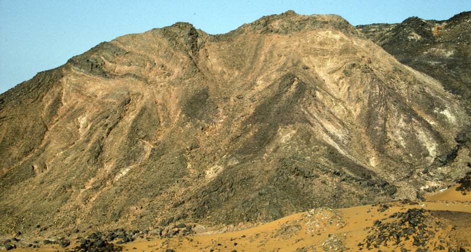
"The internal area has an average diameter of 7 kilometers and looks like
a curved and raised sandstone cylinder, covered in its upper parts with
a layer of breccias. The heights of the various elements are generally
constant. The central plateau has a maximum elevation of 678 meters, a
few meters lower than the ridgeline of the inner crown. In the inner crown
they begin with a fraction with decimetric elements. On the other hand,
on the middle plateau, a fine-grained suevite with small stone fragments
and glass rests directly on the sandstone." |
Thesis
Regardless previous conclusions about
the origin of the Aorounga structure, a sub-volcanic origin is postulated
here. The structure is basically a tectonic up-bulge of the subsurface with
a chaotic open breach in the center. The causative factor is suspected to
be the rising dome from a magma chamber in the deep subsoil, which in part
also caused wavy deformations in the sandstone layers in the outer rim. The
sandy depressions between the rings were formed by secondary subsidence as
the magma dome emptied. These slow bending and lowering processes can be seen
on the inside of the outer wall. There the sandstone layers are partly strongly
inclined inwards, but mostly already broken off sharply and sunkne. The Basenent
breccias occurring in the central part and the absence of igneous rocks suggest
that only the "hat" on the rising magma dome has reached the surface. Nonetheless
there is plenty of broken sandstone on the top.
It is also very likely that both the Aorounga and the very similar Gweni-Fada
structure have something to do with volcanism in the Tibesti of northern Chad,
the most prominent feature of which is the Emi Koussi stratovolcano. The Emi
Koussi was active 2.4 and 1.3 million years ago.
Emi Koussi was the pulsating
valve in a far-reaching magna chamber. Aorounga and Gweni-Fada are products
of temporary overpressure but have not reached an eruptive stage.
In any case, a classification of the Aorounga structure as an astrobleme is
wrong. There are no large-scale fragmentations of the sandstone layers or
ejecta outside. The magnetite-flow bearing breccias at the center of the structure
are consistently filled with shocked debris from the Basement (probably
fragments of BIF-cherts).
An outcrop containing such
Proterozoic cherts
was 2022 found in Tibesti by "FJExpeditions".
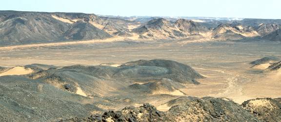
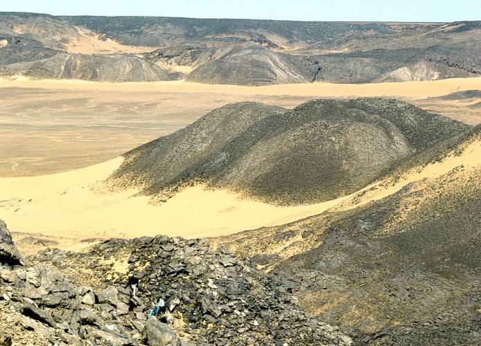
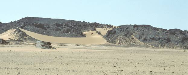
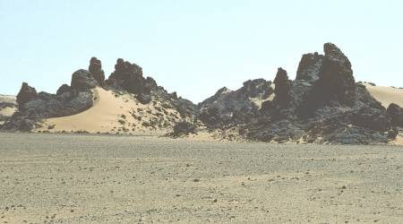
Photo Gallery
(Source: Alain Beauvilain
|
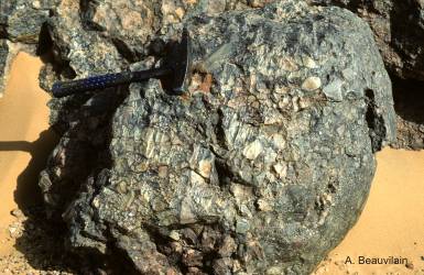
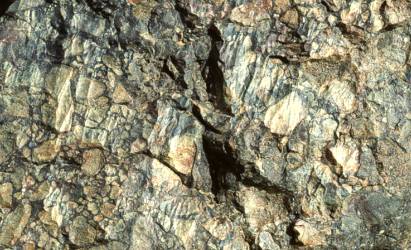
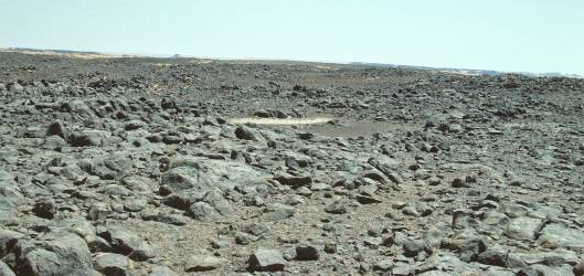
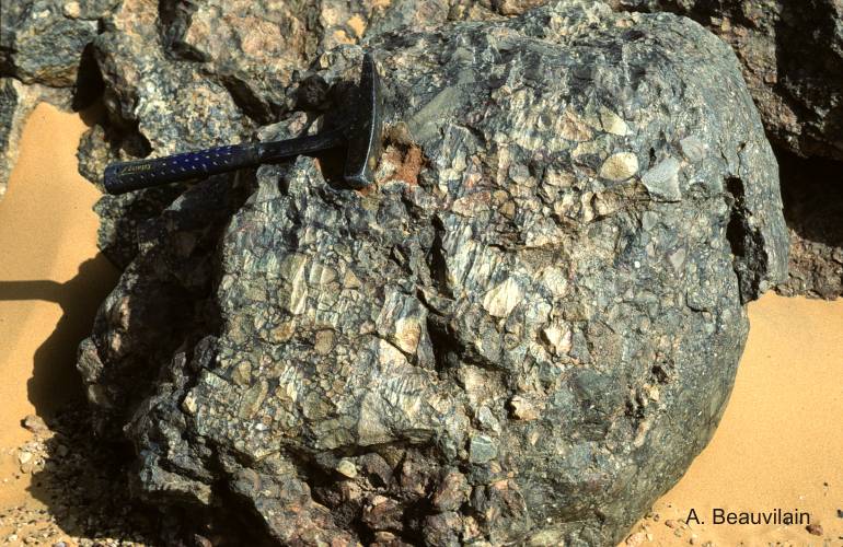
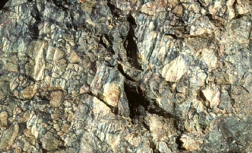
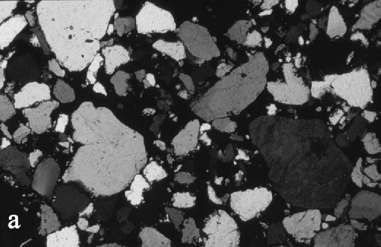
This sample of collected brecias consists of an accumulation of fragments
from the Basement (BIF-cherts ?).
|
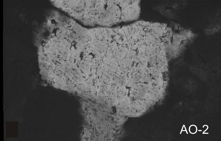
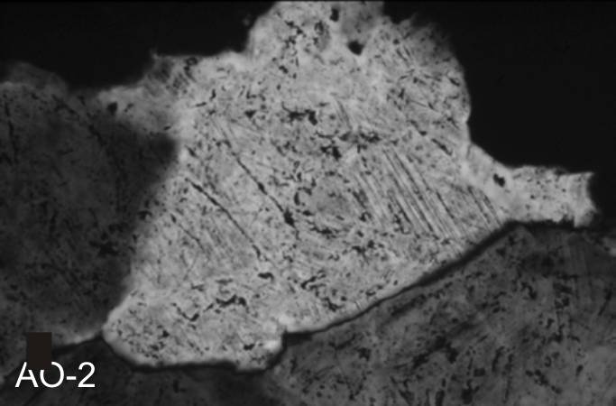
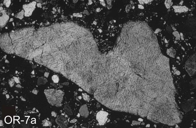
Fifteen breccias were collected
from the central elevation. From microscopic examination. Six thin section
photos are published (Koeberl et al, 2005) showing fractures in angular
splinters of BIF-quartz from the Basement (!).
Not only the fractures in angular pieses, that are siumple PFs, are interesting,
but the breccias themselves. This breccias, come from the central piek, are
an important indication of volcanic activity in the subsurface. The are originate
from gaps partially filled with a probably magneteite flow. This contains
angular and subrounded quartz pieces. This composition suggests that it is
hydro-volcanically processed Banded Iron Formation (BIF).These breccias are
comparable to the well photographed breccias from the
Gweni-Fada structure
in Chad.
The planar deformations are identical to those in debris found in the
Gilf Kebir Crater Field (GKCF)
in SW-Egypt which is undoubtedly of sub-volcanic origin !
References:
Becq-Giraudon J. F., Rouzeau
O., Goachet E. & Solages S. -- Impact hyperveloce d’une meteorite geante
a l’origine de la depression circulaire d’Aorounga au Tchad (Afrique).
Comptes Rendus Academie Science Paris 315 (II):83–88 (1992).
Vincent P.M. & Beauvilain A.
-- Decouverte d’un nouveau cratère d’impact meteoritique en Afrique: l’astrobleme
de Gweni Fada (Ennedi, Sahara du Tchad).
Comptes Rendus de l’Academie des Sciences 323 (II):987–997. (1996)
Beauvilain A.- -- L'Astrobleme
d' Aorounga, Ennedi quest. (1996)
https://meteoritestchad.monsite-orange.fr/page-55c9c6ee736a0.html
Koeberl. Ch. Reimold
W.U. Cooper G., Cowan D. & Vincent P.M. -- Aorounga and Gweni Fada impact
structures, Chad: Remote sensing, petrography, and geochemistry of target
rocks.
Meteoritics & Planetary Science 40, Nr 9/10, 1455–1471 (2005)
Brügge, Norbert
–
Clayton Craters and other crater-shaped structures in Egypt and Libya
Brügge, Norbert
–
Archean Basement outcrops of East Sahara Ghost Craton in the Western Desert
(Uweinat-Howar Uplift)
|